
Local History
A History of Bailey Cottage, River Place and Gargrave
Gargrave has a rich history of English, Roman and Scandinavian settlers. High quality farmland was created in the period following the melting of the Ice Age, with rich soil deposited by the River Aire. There were Roman forts at nearby Ilkley, Bainbridge and Elslack, with the earliest evidence of civilisation in the Gargrave area found with a Roman Villa discovered close to the village in the 1700s. ‘Kirk Sink’ represents a large rural estate in the region, with the Roman Empire influence clearly visible in the large house with mosaic floors, multiple rooms and decorations. The complex field system is still visible on the ground. The first buildings at Kirk Sink date back to around AD 150-175; a peaceful period in local history when the Roman frontier pushed further north. The Villa was abandoned in late AD 300s, around the time Scottish tribes started attacking further South into England.
Gargrave is mentioned in the Doomsday Book (c. AD 1086), listed as ‘Geregrave’ or ‘Gheregrave’. Resources at the settlement included ploughlands, meadows, woodlands for swine, a mill (valued at 9 shillings) and three fisheries. Earlier medieval records refer to the village as ‘Gerygrave’ and ‘Gayrgrave’. Unfortunately, the myth surrounding the origin of the name being the palace where the giant Gar is buried, holds no evidence! One suggestion is that the origin of the name relates to one of the Old Norse names beginning with Geir (e.g. Geirmundr, Geirlaug), attached to the Old English graef meaning grave or trench. Therefore, Gargrave could mean the grave of the Scandinavian Geirmundr. Another theory is that Old English Gara meaning ‘spear’, linked with Graf meaning wood (originally the wood from which spears shafts were cut).
St Andrews Parish Church is located in the village and dates back to 1521. The church tower escaped the devastating Scottish incursions into Northern England led by James Douglas (the ‘Black Douglas’) and Robert the Bruce. Gargrave, along with other Yorkshire towns, were stripped bare by the Scots, as part of their strategy to wage economic warfare in the region.
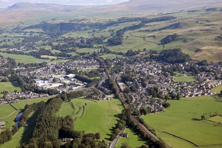
By the 1800s, Gargrave’s proximity to the River Aire, and with the recently completed Leeds Liverpool Canal running through the town, provided the perfect location for the town’s main industry; cotton manufacture. There were numerous warehouses alongside the canal, and Gargrave became a bustling transport centre and market town. Johnson and Johnson produced medical supplies that were shipped worldwide, from one of the warehouses in the village up until 2008. Barges transported lead, mined from Yorkshire Dales’ mines along the canal, and goods returned to the village included coal, corn and glassware.
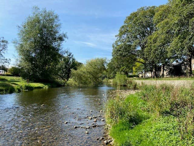
River Place is a small, historic street of terraced cottages lying right beside the River Aire, opposite the Village Green. Local records show that many of the houses on River Place were built in the 19th century to house working class families working in the cotton and textile industry. As early as 1871, families involved in cotton spinning lived at River Place. The location beside the river made the street central to Gargrave’s traditional riverside community, not only for industrial use (water power, transport, etc) but also for villagers’ recreation and play. The two sets of stepping stones seen today (called ‘Buttertub’ stones), were essential for villagers to cross the River Aire, and sit on a historically significant route with evidence of a Roman ford (discovered in 1967) suggesting ancient crossing points.
Bailey Cottage is a traditional, stone cottage which is typical of 19th century village housing in rural Northern England. The location of the cottage, alongside the river, and proximity to the village, almost certainly means that the cottage housed working class families employed in the textiles industry. The cottage was renovated in 2020, with modern interior finishes whilst making all efforts to retain period character. The attic space was also converted into a third bedroom at this time. Bailey Cottage has been running as a successful holiday cottage since and was brought into the Wayfarer Collection of character holiday homes in 2025.
A History of Coachman’s Cottage, Church Street and Settle
The first settlers to arrive in Settle are thought to be the Angles that arrived in the area from the West, around the 7th century. Indeed, the name Settle derives from the Anglian word for settlement. A few centuries later, descendants of Scandinavian invasions of Ireland continued West into the area, creating a Norse-Irish settlement. This remained the case until 1069-1071 with the ‘Harrying of the North’; a series of military campaigns led by William the Conqueror to subjugate Northern England. Anglo-Saxon, Anglo-Scandinavian and Danish rebels refused to meet him in battle, so he decided to starve them out by laying waste to the Northern shires using scorched earth tactics. As a result, much of the area was described as ‘Waste’ on the Doomsday survey. William succeeded in relieving the aristocracy of their positions and replacing them with Norman aristocrats, with the land at Settle granted to Roger de Poitou.
By the 12th century a market charter was granted, and the market square developed in the town. The charter from King Henry III allowed Settle to hold a market each Tuesday; which is still in place today. Early stone buildings existed in the area, such as barns and sheep houses, built by and for the monasteries, but once the market charger was granted, houses, shops and workshops were required and built around the market square.
In the 17th century Settle was prospering as a local trade town, with it’s remoteness meaning trade was undertaken along pack horse trails and drovers’ roads along the hilltops. At this point in time, textile industrialists, traders and landowners campaigned for a turnpike to connect growing industrial towns nearby, The Keighley and Kendal Turnpike was a road built in 1753, connecting the two important trading towns, via Settle. This was not only the start of a golden age for industry and transport, but also for the Coaching Inns such as the Spread Eagle Inn and The Golden Lion catering for coach traffic.
By the late 18th century, cotton spinning became the town’s main employment, with Settle having five mills employing more than 300 people. The Settle to Carlisle railway line was opened in 1875, with Settle railway station along with goods warehouses, cattle pens, signal boxes and water cranes.
Settle still holds its market on a Tuesday and is now a tourist hot spot in the area. With the nearby Yorkshire 3 Peaks providing a unique challenge for hikers, runners and cyclists, and the various cafes, restaurants and bars surrounding the market square. Ye Olde Naked Man Cafe is thought to be the oldest cafe in the country, dating back to 1663.
Coachman’s Cottage is part of a row cottages, hidden away in a small courtyard, just off Church Street. Church Street is an historic thoroughfare in Settle, historically connecting the centre with the Parish Church at Giggleswick. The narrow ginnel that runs parallel to Church Street, originally allowed people to walk from Kirkgate to the Parish Church over the first river bridge, rather than getting their feet wet at Kendalman’s Ford!
Coachman’s Cottage is a traditional, stone cottage which is typical of 19th century village housing in rural Northern England. The cottage is part of a row of houses that, along with the large building across the courtyard, were originally used as a local bakery. The cottage was renovated in 2020, with modern interior finishes, whilst making all efforts to retain period character. Coachman’s Cottage was brought into the Wayfarer Collection of character holiday homes in 2025.